OUR TRAILS
A wide variety of trails emanating from four different trailhead locations provide the public free access to areas of spectacular natural beauty. Enjoy peaceful strolls along undeveloped shorelines of Lake Martin, hike through rugged rock formations, climb historic fire lookout towers, awe at the majesty of old growth hardwoods, marvel at hillsides covered in mountain laurel, catch your breath on hilltops overlooking sweeping vistas, search for birds and wildlife in unspoiled habitats, find delicate wildflowers, listen to the music of clear flowing streams, renew your spirit in the peace and solitude. Whether you have an hour or all day, whether you want a gentle walk or a physical challenge, there is a trail just made for you.
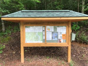
For Google Map directions to any of our trail locations visit our Show Me The Way Map by clicking here!
IMPORTANT : Please help us keep our trails litter free and beautiful! Pack your trash out with you. Camping is not allowed on any of the properties that host our trails. ALL PETS MUST BE ON A LEASH AND IN FULL CONTROL BY THEIR HUMAN COMPANIONS. Also, we do not allow bicycles, motorized vehicles or horses on our footpath only trails. Please comply with these rules so as to make hiking our trails a safe and pleasant experience for all concerned.
Smith Mountain
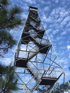
Historic Fire Tower, Educational Exhibits, and Trails
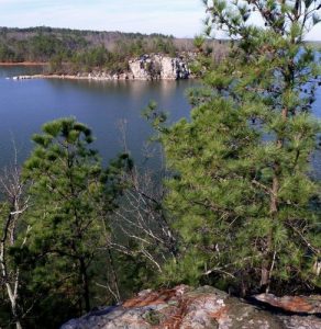
Smith Mountain is the tallest elevation on Lake Martin’s shoreline and once served as the district office of the Alabama Forestry Commission. Atop the jagged peak is a historic 90 foot fire lookout tower. Completed in 1939, it was the central tower of a six-tower fire protection network. In addition to the tower, boys from the Civilian Conservation Corp built a ranger station, cistern, shop building, map tables, picnic area and other amenities. Signature rockwork of the Civilian Conservation Corp is still visible. Abandoned by the Forestry Commission in 1980, Smith Mountain became a dumping ground and the tower fell into disrepair. In 2010, CRATA obtained title to Smith Mountain and thanks to numerous donors contributing money, materials, and volunteer labor, the tower was restored to a stronger and safer condition than when it was new. The cabin of the tower arguably offers the most spectacular panoramic view in Alabama with clear waters of Lake Martin below and mountains of Talladega National Forest visible to the North. In 2018, CRATA completed another major project on Smith Mountain. A series of kiosk mounted displays, wayside exhibits, and tower mounted signage describe the natural and cultural history of the area, offering visitors an educational experience in an inspiring outdoor setting. The tower was recently officially named the Jerry W. Bynum Fire Lookout Tower in honor of the man who spearheaded its restoration.

Cherokee Ridge Alpine Trail At Overlook Park
Beautiful Park, Scenic Trails and near-by Historic Fire Lookout Tower
The Cherokee Ridge Alpine Trail and Overlook Park provide some of the most scenic and panoramic views you can get and still have both feet on solid ground.
CRATA’s first trails constructed in 2004 consist of three (3) trails for a total of 7.2 miles. All three trails are tied together so you can hike from 1 mile to 7 miles with several combinations.
Just a few hundred yards down the highway from the park stands the Jimmy K. Lanier Fire Lookout Tower. This is a newly renovated, historic fire lookout tower that stands at 110 feet tall and is open to the public to climb and enjoy. The tower is separate from the Overlook Park and has its own parking lot. The view of Lake Martin from the cab of this tower is incredible!
The James M. Scott Deadening Alpine Trail
Challenging Trail Along Rocky Bluffs
The James M. Scott Deadening Alpine Trail is a 4.2 mile loop trail that is more challenging than the other trails created by CRATA, but also more rewarding. You can take the crossover route and hike only 3.1 miles. There is also an emergency trail to the parking lot at this location.
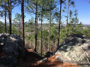
The cliffs of the Tallapoosa River, the Needles Eye, and Jasmine Bluff are just a few of the unique rock formations that await the hiker. Spectacular vistas of Lake Martin, thickets of mountain laurel and rhododendron will delight the hiker in late April and early May.
John B. Scott Forever Wild & Cherokee Bluffs Dam Railroad Trails At Yates Lake
Historic Trails Through Old Growth Forest and Waterways
There are two primary hiking trails on this 6000 acre wildlife management area owned by Alabama Forever Wild. (Click here to visit Forever Wild website.)
The John B. Scott trail is 4.7 miles that weaves along the Tallapoosa River through old growth hardwoods and along several beautiful, flowing creeks.
The Cherokee Bluffs Dam Railroad trail follows the old, historic railroad bed that was built in the early 1920’s and used in the construction of Martin Dam. You can hike 2.7 miles to the Channahatchee Creek or you can follow either the Highline or Lowline railroads and proceed to the highest point in Elmore County: Saddle Rock Mountain.