 |
|
||
|
Author: Walt Hutcheson
|
|
||
|
|
||||
|
|
|
|
Friends of CRATA Newsletter
|
Overlook Tower Project
As we announced in December of 2022, CRATA is currently working on our biggest project to date! We are refurbishing and erecting a second fire lookout tower on the south end of Lake Martin. The tower will stand on CRATA property, purchased from Alabama Power, and located adjacent to Overlook Park, overlooking our trails on the south end of the lake. The tower will stand at 110 feet on one of the highest points of Cherokee Bluffs and will provide another fantastic view of the lake for the public to enjoy!
At the end of 2021 CRATA acquired a historic fire lookout tower located in Virginia and a group of our volunteers traveled to Virginia, disassembled the standing tower and transported it back to Alabama. Most all of our efforts in 2022 were focused on completely refurbishing and re-engineering the old tower for strength and safety. We also went through a months long process of approval and purchase of land on which to erect the tower near our trails. This year we have continued working on the tower structure, but our primary focus has been on preparing the site and building a foundation for the tower to stand on. This endeavor has been a long, highly technical and labor intensive process (thousands of volunteer man hours), which requires a lot of coordination with and between numerous people. We suffered several delays this year from weather and scheduling and unfortunately this has dashed our goal and hopes of completing the tower this year. Our goal is now to complete the tower and open it to the public sometime during the summer of 2024. The outpouring of support from our followers has been fantastic, not only financially but with volunteer labor, materials and equipment also. For those of you that have already helped us with this project, we thank you from the bottom of our hearts! For those that would like to contribute, click on the links at the bottom of this newsletter to donate or volunteer. Remember donations of $250 or more will get your name on a permanent cast metal plaque, that will be located at the tower site.
We want to thank our major partners (so far) that are making this project plan become a reality!
Tower Structure: Mike and Christina Upton – Sedley, Virginia
Land: Alabama Power Company, F. Allen and Louise K. Turner Foundation
Land preparation: Steve Fuller, Chris McConnell, Clint Weldon, Red Hill and Union Volunteer Fire Departments
Structural/Civil Engineering: Salvatore (Sal) Granada, PE,SE, Opelika, AL
Building Site & Structural Layout: Steve Martin Engineering, Butch Nabors
Tower Foundation: Wayne Bylsma, Sitemix, Contour Engineering, Paul Wright, Eddie Voss
Electrical: Dixie Electric, Jimmy Jehle
Metal Fabrication: Chris George, Wendell Hornsby, Diversified Steel
Lumber (Milling, Treatment, Purchase): Jerry Bynum, Arnold Lumber Co., Russell Do-It Center – Eclectic
And many others that make things happen: Tallapoosa Publishing, Lake Martin Resource Association, Tallapoosa County, Lake Martin Tourism Association
Most of all, our dedicated volunteers and donors without whom there would be no CRATA !
Thank you all so very much!!
If you would like to view a photo gallery of our tower project work efforts, click here.
Trail News
Hiking trails are of course our primary business and the heart of our organization. Although CRATA’s primary focus this year has been on the construction of the new fire lookout tower, maintaining and looking after our trails continues and remains a high priority. This year has been mostly about storm clean-up! The F1 tornado that crossed the southern end of Lake Martin, early this Spring, downed hundreds of trees on our trails at Overlook Park and on The James Scott Deadening Trail. We had to close the Deadening trail, for several weeks as it was unpassable and dangerous to hike in several areas. Crews of CRATA volunteers spent several weeks cutting approximately 200-300 downed trees from across the trails. We also had numerous blow downs on our trails at Smith Mountain. Much effort and many hours from the trail managers and our volunteers has gone into maintaining our hiking trails for our visitors this year! Other issues at the trails this year have included continued graffiti vandalism at Smith Mountain and 4-wheelers damaging our trails on the Yates Forever Wild property.
Near future plans and projects for our trails include plans to work with State Lands and Forever Wild to expand our existing hiking trails on the Yates Forever Wild land tract. We hope to open a new trail and begin developing additional trail sections along the shoreline of Yates Lake in 2024.
If you have questions or would like to report issues with our trails, we welcome you to email us at admin@crata.org or call at (334) 245-4534.
Thank You!
All of us at CRATA want to thank each of you for your continued support of all of our projects over the years in our efforts to provide free public access to hike quality trails, and to enjoy and learn about the incredible diversity of nature in the Lake Martin area. We continue to be extremely excited about our new tower project, and we are anxious to see it to completion. This tower construction project is extensive and costly! Many of you have already made donations to help us see this through and we are extremely grateful!. We hope you all will please consider CRATA for one of your year-end donations. We are a 501(c)(3) nonprofit organization and all donations are tax deductible. You can donate online using our secure website donation form by clicking on this link or mail your donations to:
Cherokee Ridge Alpine Trail Assoc.
PO Box 240503,
Eclectic AL 36024
The names of donors making donations of $250 or more will be added to a permanent, cast metal plaque, to be located at the tower, just as we did at Smith Mountain.
Again, thank you all for your continued support and financial help! We hope to see you all on the trails (and the tower soon)!
Steve Thomas
President – Board of Directors
Sthomas1654@gmail.com
Jimmy Lanier
Founder/Treasurer – Board of Directors
Jlanier2@elmore.rr.com
Helpful links:
CRATA website
Donate to CRATA
Volunteer
Overlook Tower Brochure
Tower Project Photo Gallery
![]()
Jonathon Gogan, Steve Thomas and Harold Banks cut and remove logs from the trail.
Monday April 17, 2023 – Jim Scott Deadening Trail Re-opened: After a concentrated effort by CRATA leadership and our volunteers, all downed trees across the trail, from the recent tornado, have been cut and cleared from the trail. The entire trail is now open to our hikers. There is still clean-up work to do, but we have been able to clear the trail to a point that hikers can now traverse the entire trail, There are still a few stepover and walk under trees that remain and other debris that we will work on in the near future, Please let us know if you encounter any safety problems that need to be addressed. We really appreciate our volunteer crews stepping up helping get this work done for our hikers! This morning we had a group that was very skilled with chainsaw work and that helped tremendously. We were able to divide and conquer with two crews working different problem areas.
Volunteers working the trail today included: Steve and Julia Thomas, Jimmy Lanier, Mike Wilson, Bill Garnett, Harold Banks, Walt Hutcheson, Bob Keyser, Daniel Keyser and Jonathon Gogan.
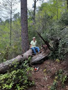
Julia Thomas requesting a bigger saw!
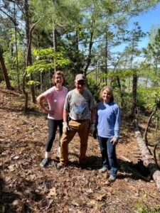
Betty Cannon, Jimmy Lanier and Becky Franks making a plan.
Work Continues on the Jim Scott Deadening Trail Damage.
Wednesday, April 5,2023 – Today our crew of volunteers hit the Jim Scott Deadening Trail to continue the ongoing effort to remove downed trees from the recent F-1 tornado that crossed Lake Martin. The lower, northern portion of the trail was directly in the path of the tornado and sustained heavy damage, with hundreds of downed trees. The upper, southern part of the trail received less damage but still had over fifty downed trees. The work crew today was working to clear the trees on the upper section of the trail, in an effort to get most of the Deadening Trail cleared and re-opened for our hikers. The efforts were successful and the upper portion of the trail has been re-opened to the public. At the current time hikers can hike that 3.1 mile section of the trail and by-pass the lower 1.1 mile section. We have signs in place for guidance. The northern end of the peninsula is so heavily damaged that it will take crews months to return that section to a useable trail. It is completely impassible at this time!
Volunteers working hard on the trail today were Jimmy Lanier, Steve and Julia Thomas, Harold Banks, Bill Garnett, Clay Humphries, Becky Franks, Betty Cannon, Doug Lewis, Robert Keyser, Graham Yuill and Hank Morris.